Air masses and weather systems
Air masses
The mixing of polar and tropical air within the westerly wind zone in mid-latitudes means weather here is extremely variable. The thermal variation and wave patterns of westerlies cause depressions and anticyclones, the main drivers of our weather.
Weather is affected by the dominant AIR MASS.
Air Masses are large bodies of air whose physical properties, moisture content and lapse rate are uniform. The uniformity of an air mass depends on:
Lapse rates, stability and instability
The surface air temperature reflects the prevailing air mass characteristics.
The mixing of polar and tropical air within the westerly wind zone in mid-latitudes means weather here is extremely variable. The thermal variation and wave patterns of westerlies cause depressions and anticyclones, the main drivers of our weather.
Weather is affected by the dominant AIR MASS.
Air Masses are large bodies of air whose physical properties, moisture content and lapse rate are uniform. The uniformity of an air mass depends on:
- Source area
- Direction of movement and characteristics of that air mass
- The age of the air mass
Lapse rates, stability and instability
The surface air temperature reflects the prevailing air mass characteristics.
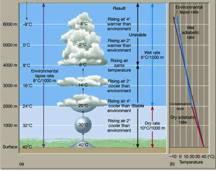
Environmental lapse rate is the rate at which temperature decreased with height, it is roughly 6 degrees per 1000 m.
Within this, the pockets of warmer air rise, expand and cool and the cooler air compresses and falls until they are in equilibrium with the surrounding air. However, air may be forced to rise due to mountain barriers or by cold air masses, this is ADIABATIC COOLING.
- Adiabatic cooling is an internal change without external gains or losses.
Rising air pockets cool at the ADIABATIC LAPSE RATE (ALR). If the
cooling does not result in the air becoming saturated, it is known as the DRY ADIABATIC LAPSE RATE (DALR), which is constant at 10 degrees per 1000 m.
- If the saturation level is reached, condensation occurs, heat is released as water vapour turns into water, this follows a SATURATED (WET) ADIABATIC LAPSE RATE (SALR) which varies around 5 degrees per 1000 m at surface levels and 9 degrees per 1000 m in the troposphere where there is less moisture in the air.
The DALR and SALR rates may vary from source to source. Use the rate cited in the reference material you are using at the time.
fronts
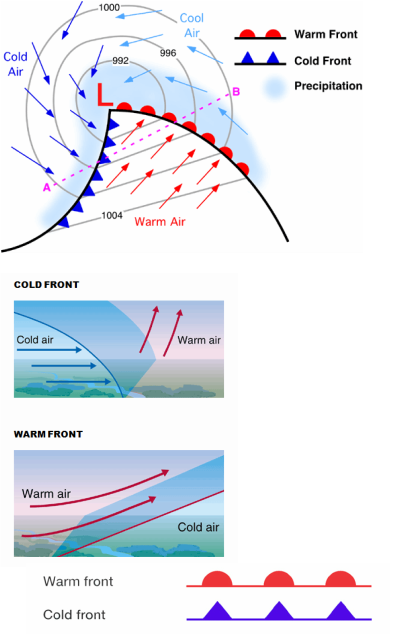
If colder air is replacing warmer air, it is a cold front, if warmer air is replacing cold air, then it is a warm front.
Cold Front
A cold front is a transition zone where a cold air mass replaces a warmer air mass. The cold fronts move form northwest to souh east. Cold fronts are represented by a solid line with blue triangles pointing towards the warmer air and in the direction of movement
Warm Front
Warm fronts are regions where warm air replaces a cold air mass. Warm fronts usually move from southwest to northeast .The air behind a warm front is warmer and moister than the air in front of it. On a weather forcast a warm front is represented by a solid black line with red semi circles pointing towards the colder air mass and in the direction if movement.
Occluded front
The occluded front is formed when a cold front progresses eastward while the warm front progresses northeastward. This results in the cold front catching up to the warm front in the mature to end stages of a cyclone's cycle. When the cold front catches the warm front, the cold air undercuts the warm air creating a very stable situation. The symbol for an Occulded front is alternating purple triangles and half circles pointing in the direction the front is moving.
british isle air masses
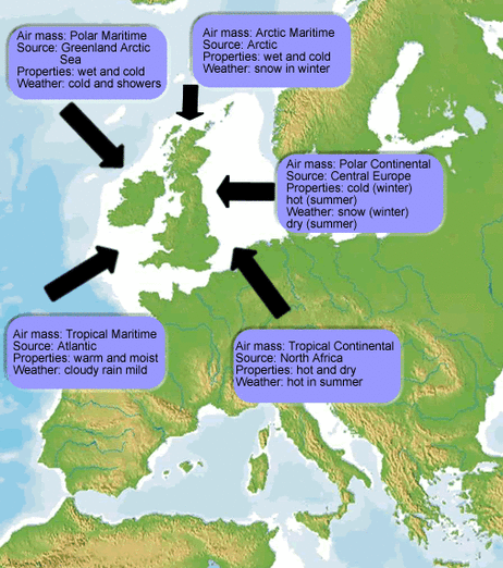
The British Isles is affected by a variety of different air masses, including:
- Polar maritime
- Arctic
- Polar continental
- Tropical continental
- Tropical maritime
air stability
Stability
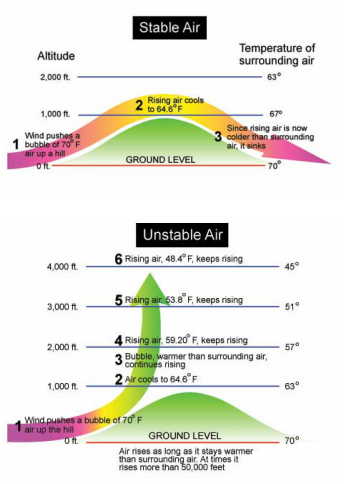
STABLE air is cooler and denser then surrounding air and so sinks. When the air temperature is higher than the surrounding environment, it will rise as it is less dense and will be UNSTABLE
Stable air means that the weather is likely to be calm. It may rain or snow slowly and steadily, it may be sunny, but the weather will not change quickly. Unstable air means that the weather might change quickly with very little warning. Unstable air leads to sudden thunderstorms.
Follow this link to compare stable and unstable air: webweather
CONDITIONAL INSTABILITY. This is when the air parcel’s instability is conditional on being an uplift trigger as the air is cooler than the environment at low levels and warmer at high levels. The uplift trigger can be: masses of cold air (frontal), strong convection currents (convectional) and mountains or form of relief barrier (Orographic). This a characteristic of Britain.
extreme weather: tornadoes unstable air
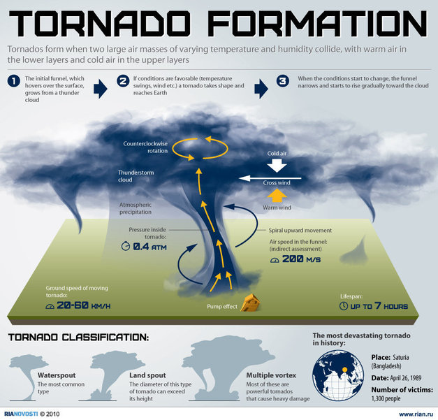
Tornadoes usually occur in the spring, forming in the clouds of thunderstorms.
To form a tornado, the following is required:
- Moisture in the air within the lower to mid atmospheric levels.
- Unstable air that continues to rise from the ground
- A lifting force, the most common of which is rising hot air from the ground.
When the conditions are all present, humid air rises, cools and condenses into clouds which forms thunderstorms. The rising air is called an updraft which is where the tornado forms.
The strongest Tornadoes form close to the edge of the updraft, near to the descending downdraft caused by the thunderstorms with falling rain or hail. This is why heavy rain or hail often precedes the tornado.
Tornadoes are most commonly found in an area stretching from Texas to Iowa, the area known as Tornado Alley.
Scales of tornadoes.
The most well known scale to measure tornadoes is the Fujita scale. This ranges from F0 which damages trees to F5, the most severe, which can tear away buildings. In the United States, 80% of tornadoes are F0, with only around 1% recorded at F4 or F5.
Follow this link to see an interactive animation of how tornadoes form and test out the different tornado scales.
Animated guide: Tornadoes BBC
Extreme weather: news flash oklahoma 2013
On the 20th May 2013 a Tornado rated F5 tore through Moore Oklahoma. The peak winds were 210 miles per hour, killing 24 people and injuring 377 others. The tornado originated from a larger weather system that produced several other tornadoes over the previous two days. The Tornado touched down west of Newcastle at 2:56pm, lasting for 39 minutes over a 17 mile path. Despite being a tornado area few homes and neither of the schools had purpose-built storm shelters. The tornado is estimated to have caused caused $2 billion dollars of damage, effecting the areas of Grady, McClain, Cleveland and Moore city in Oklahoma.
