Local weather and climate
Local and regional winds
HIGH-ALTITUDE WINDS are much stronger than surface winds due to lack of friction.
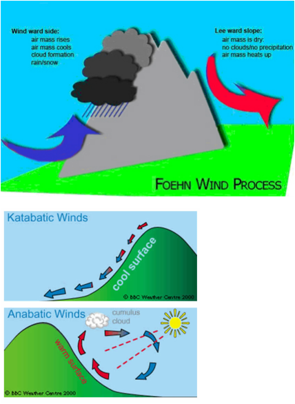
Mountain barriers produce the FÖHN or FOEHN EFFECT. This is when a warm, dry wind develops on the lee side of a barrier as stable air is forced over it. As the air ascends over the barrier it cools to dew point resulting in precipitation, further cooling is at the saturated adiabatic lapse rate. The air warms at the higher dry adiabatic lapse rate as it descends creating rising temperatures and lower humidity.
Mountain barriers funnel wind through valleys and across passes, producing strong winds as the air is forced to constrict and accelerate.
In mountain areas there are local mountain an valley winds these are known as ANABATIC (up-slope) and KATABATIC (down-slope) winds.
ANABATIC WINDS occur in warm sunny conditions on the sides of valleys. Due to the heating of the valley sides the air flows upwards. At the same time a general VALLEY WIND develops flowing along and up the valley. The situation is reversed at night as cooler, denser air flows down-slope. This is a KATABATIC wind, which has denser air, flowing along and down the valley as a MOUNTAIN WIND. This is shown opposite.
KATABATIC air sometimes causes frost pockets or frost hollows as cold, dense air accumulates in valley bottoms. This is the result of night time cooling giving a temperature change creating RADIATION FOG in the valley bottoms as moisture in the air condenses.
Land and Sea Breezes are generated by temperature induced air movements similar to mountain winds.
british isles weather
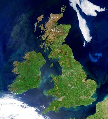
The British isles weather is associated with different air masses and with high and low pressure systems
High-pressure weather
When air sinks there is minimal condensation leading to clear
skies and high temperatures in the summer and low temperatures in the winter. A high-pressure area over the British isles is known as a BLOCKING ANTICYCLONE or BLOCKING HIGH as it causes the easterly path of mid-latitude depressions to move further north leading to long periods of settled weather.
Low-pressure weather
Rising air leads to condensation, cloud formation and precipitation. Mid-latitude depressions bring wet, cloudy, windy weather to Britain.
Follow the link below to explore a range of case studies about British weather: http://www.metoffice.gov.uk/education/teens
Key UK case studies are:
Global case studies:
High-pressure weather
When air sinks there is minimal condensation leading to clear
skies and high temperatures in the summer and low temperatures in the winter. A high-pressure area over the British isles is known as a BLOCKING ANTICYCLONE or BLOCKING HIGH as it causes the easterly path of mid-latitude depressions to move further north leading to long periods of settled weather.
Low-pressure weather
Rising air leads to condensation, cloud formation and precipitation. Mid-latitude depressions bring wet, cloudy, windy weather to Britain.
Follow the link below to explore a range of case studies about British weather: http://www.metoffice.gov.uk/education/teens
Key UK case studies are:
- Boscastle Floods 2004: Low pressure system
- April winds 2012: Low pressure system
- Uk indian summer 2012: high pressure system
Global case studies:
- Russian Heatwave 2010: High pressure, Blocking high
system - European Heatwave 2003: High pressure system
extreme weather uk: Boscastle floods
BOSCASTLE FLOODS
16th August 2004
The extensive floods were caused by the anticlockwise cyclonic winds creating areas of low pressure, arriving from a
south-westerly direction. The air was a warm and moist tropical maritime air mass. This caused thunderstorms and heavy rain. This caused the air to collide increasing the rate of ascent and very heavy rain; approximately 75 mm of rain fell in two hours (normally the amount that falls in the whole of august). The heavy rain caused two rivers to burst their banks. Approximately two billion litres of water rushed down the valley into Boscastle.
For further detail of the Boscastle Flood case study follow this link: http://www.metoffice.gov.uk/education/teens/case-studies/boscastle
Follow this link to read, look at and hear news reports, interviews and photos from the Boscastle floods: http://www.bbc.co.uk/cornwall/uncovered/stories/august2004/boscastle_floods.shtml
Urban climate
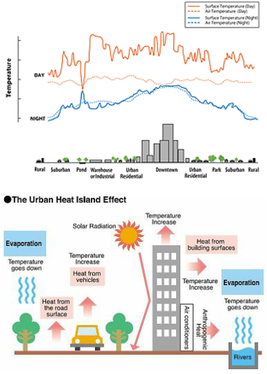
The Urban Heat Island Effect
Urban areas are 5-6 degrees warmer than surrounding rural areas. This is most noticeable at night under calm anticyclonic conditions when cooling is higher in rural areas. The edge of a city is marked by a sharp difference in temperature.
Contributing factors to the generation of the Urban Heat Island Effect are:
The diagram opposite shows these factors in context.
Precipitation
Cloud cover is greater over urban areas as so is precipitation, 10% greater than rural areas. This is explained by convection currents created by the heat island effect and the greater concentration of condensation nuclei in the form of aerosol particles which trigger thunderstorms.
Wind
Wind speeds are reduced in urban areas due to the roughness of the surfaces and increased friction. However, tall buildings arranged in straight line create a CROYON EFFECT funneling the winds like in valleys.
Pollution
Atmospheric composition is changed by aerosols, industrial gases and car exhausts fumes which bring about smogs,fogs and chemical changes as well as affecting incoming and outgoing radiation. Pollution distribution around urban areas is marked by a pollution dome forming under the temperature inversion that forms. Light winds displace the pollution so that plumes of pollution extend into adjacent rural areas downwind.
A case example for the effects of Pollution: Smog is the London Killer Smog 1952
Urban areas are 5-6 degrees warmer than surrounding rural areas. This is most noticeable at night under calm anticyclonic conditions when cooling is higher in rural areas. The edge of a city is marked by a sharp difference in temperature.
Contributing factors to the generation of the Urban Heat Island Effect are:
- Heat loss from buildings
- Size of the city
- Density of buildings
- Burning of fossil fuels
- Heights of buildings trapping heat
- Different reflective surfaces giving a complex pattern of re-reflection and trapping of heat
- Rapid removal of surface water so less heat is used in evaporation
- Lower wine speeds reducing heat loss
- Temperature inversions trapping heat
The diagram opposite shows these factors in context.
Precipitation
Cloud cover is greater over urban areas as so is precipitation, 10% greater than rural areas. This is explained by convection currents created by the heat island effect and the greater concentration of condensation nuclei in the form of aerosol particles which trigger thunderstorms.
Wind
Wind speeds are reduced in urban areas due to the roughness of the surfaces and increased friction. However, tall buildings arranged in straight line create a CROYON EFFECT funneling the winds like in valleys.
Pollution
Atmospheric composition is changed by aerosols, industrial gases and car exhausts fumes which bring about smogs,fogs and chemical changes as well as affecting incoming and outgoing radiation. Pollution distribution around urban areas is marked by a pollution dome forming under the temperature inversion that forms. Light winds displace the pollution so that plumes of pollution extend into adjacent rural areas downwind.
A case example for the effects of Pollution: Smog is the London Killer Smog 1952
Forest climate
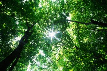
Forests have a different surface and means of modifying their local climate.
The climatic features of forests vary according to:
The effects of forests on the surface climate and insolation levels are:
The climatic features of forests vary according to:
- The size of forest
- Height of trees
- Density of trees
- Nature of trees
The effects of forests on the surface climate and insolation levels are:
- A wide range of albedos
- Most of the solar energy is trapped at tree top level
- In dense forests little insolation reaches the forest floor
- Wind speeds are reduced
- Humidity levels are modified
- Increased evapotranspiration may increase local rainfall
- There may be a small diurnal temperature range.
