Atmospheric circulation
The uneven distribution of insolation energy is the main factor that causes atmospheric circulation. Heat is transferred within the atmosphere and oceans, recognisable as wind patterns, ocean currents and pressure belts from low latitudes to high latitudes, redistributing heat from surplus areas to deficit areas. At a global scale atmospheric circulation patterns are known as GLOBAL CIRCULATION MODELS.
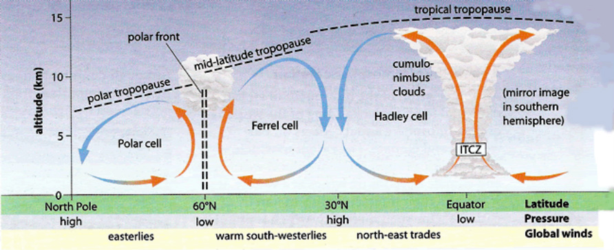
Upper air circulation- Tri-cellular model
Inter-tropical convergence zone
Also know as the Inter-tropical discontinuity. This is a belt of low pressures flanked by clouds and rain, it moves in correlation to the Sun’s movement.
Hadley Cell
This is a cell of atmospheric motion. The warm air rises at the equator, creating areas of low pressure. Reaching the Tropopause, heat is lost and the air moves pole-wards. The air sinks in the sub-tropics as it is colder and denser. The sinking air causes areas of high pressure on the surface. The air then returns towards the tropics to replace the rising air.
Polar cell
In the Polar Regions, cold dense air sinks and spreads towards the lower latitudes. Here, it warms and rises spreading out towards the Tropopause, moving pole-wards again to replace the sinking air.
Ferrel cell
In between the Polar and Hadley cell lies the Ferrel cell, driven by the movements of the neighboring cells.
The Tri-cellular model of 1856 is inaccurate due to the recognition of seasonal shifts of the sun’s position, energy transfers in mid-latitudes and most importantly the effect of Jet streams and Rossby waves, which disrupt north-south air movements in Ferrel cells.
Atmospheric motion
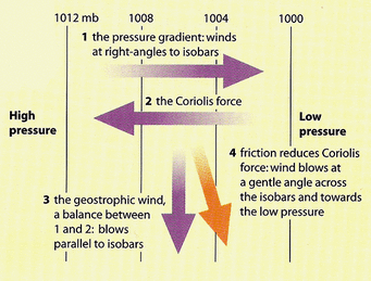
The horizontal movement of air is controlled by:
The horizontal movement of air is controlled by:
- Pressure Gradient force- This is the main driving force of global winds. This creates a wind from high-pressure, surplus areas to low-pressure, deficit areas. The closer isobars are together, the stronger the wind is.
- Coriolis force- This is the deflection of wind due to the Earth’s rotation. Deflecting right in the northern hemisphere and left in the southern, with an increasing effect towards the poles. It is not present in the equator.
- Geostropic wind- In mid-latitudes, the Pressure Gradient and Coriolis force are balanced. Therefore, air moves parallel to the isobars rather than from regions of high pressure to low pressure.
- Centripetal force- Air moving towards a low-pressure area in a defected path accelerates towards the centre of low pressure
- Frictional forces- Frictional drag from the Earth's surface decreases wind speed and modifies it's direction, crossing isobars as it moves from high-pressure regions to low-pressure regions areas.
Mid-latitudes
Upper-air, westerly winds are called the ROSSBY WAVES. Varying on season, there can be 2-5 waves. They are influenced by relief barriers, land and sea differences and can last for up to 6 weeks. These waves, in conjunction with jet streams, directly cause surface depressions and anticyclones. The wave form depends on:
Upper-air, westerly winds are called the ROSSBY WAVES. Varying on season, there can be 2-5 waves. They are influenced by relief barriers, land and sea differences and can last for up to 6 weeks. These waves, in conjunction with jet streams, directly cause surface depressions and anticyclones. The wave form depends on:
- Thermal differences between polar and tropical regions
- The rotation of the earth
- Major relief barriers i.e. Rocky Mountains
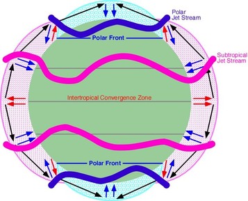
Jet streams
These are very high-speed narrow bands of wind, found where the temperature and pressure gradients are greatest in the upper atmosphere.
The Polar Front Jet Stream
This separates the polar and tropical air in waves of troughs and ridges; it is situated between 35 to 55 degrees. The ridges take warm air up anticlockwise, creating areas of unstable, low surface pressure. The Troughs bring cold air descending clockwise to the surface creating dry, stable conditions with high surface pressures.
The Sub-Tropical Jet Stream
With lower wind speeds and less pronounced waves, this stream is located at 25 – 30 degrees of latitude.
The Easterly Equatorial Jet Stream
This jet stream is linked to the Indian monsoon and therefore is seasonal.
Global pattern variation
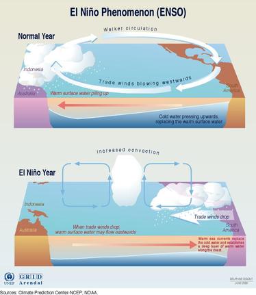
El Niño
Occurring every 4-7 years, El Niño is a naturally occurring phenomenon. There is a shift in the temperature structure in the pacific ocean, resulting in warm water occurring in the eastern pacific off coastal Peru. This produces low pressures as air above the warm water rises weakening the trade wind circulation. This leads to high rainfall along the South American east coast and drier conditions in the western pacific over Australia and Indonesia.
A strong easterly wind flow can increase upwelling, cooling the sea surface temperatures. This is La Nina.
Both phenomena can have global weather impacts. For example, strong El Niño events result in a weak Atlantic Hurricane season; La Nina events can cause drought in California.
